
Projects
*Projects listed below were completed under the direct project management of Jaime A. Taynor during a previous employment

MCLB Yermo/Nebo and NAS El Centro – Locations of all wet utilities including sanitary sewer, storm sewer, domestic water, fire water, and industrial sewer. Detailed notes were included on the final report that included the depth of the utility, condition, material used in the construction, direction of flow, type, and the orientation of all fire hydrants. GPS and conventional survey means were used in the collection of data.
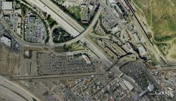
MCB Camp Pendleton Gas Line Repair/Replacement Surveys – The topographic surveys consisted of over 65,000-feet of military roadways using RTK-GPS and conventional total stations covering the width of travel and utility corridor. The locations of all utilities including sanitary sewer, storm sewer, domestic water, fire water, industrial sewer, communication, gas, electric and steam along with utility mark-outs were recorded and added to the final drawings. As with most of Camp Pendleton, these surveys were performed in environmentally and archeologically sensitive areas and close coordination was required with monitoring personnel.
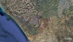
 Dam Deformation Monitoring – Performed
high precision GPS and vertical survey for surface monitoring and deformation.
Project consisted of monitoring 12 monuments on the dam, 4 existing control
points adjacent to, and the setting of 4 additional control points outside of
any possible influence of movement from the dam. Static GPS and digital levels were used to control the
project.
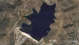
Dam Deformation Monitoring – Performed
high precision GPS and vertical survey for surface monitoring and deformation.
Project consisted of monitoring 12 monuments on the dam, 4 existing control
points adjacent to, and the setting of 4 additional control points outside of
any possible influence of movement from the dam. Static GPS and digital levels were used to control the
project.

AT&T, Sprint, Verizon, Cricket, Etc – Performed GPS location, topographic surveys, boundary surveys, preliminary title reviews, tower detailing, lease descriptions, and exhibits on over 3000 cellular sites in California, Arizona, New Mexico, Colorado, Nevada, Oregon, Washington, and Idaho.
